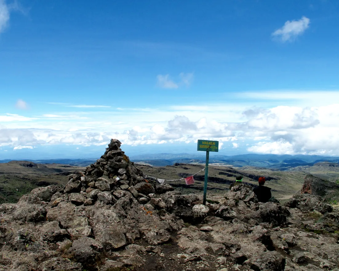
Mount Elgon
Trek Wagagai Peak (4,321m) across Mount Elgon's caldera via the Sasa, Sipi, or Piswa trail, with Sipi Falls as the classic add-on — fees, routes, best months.
Photo: Kristina Just, CC BY-SA 2.0, Wikimedia Commons
Why go
Mount Elgon doesn’t look like the postcard version of an African volcano. There’s no single symmetrical cone — instead, a vast, worn shield of a mountain straddling the Uganda-Kenya border, at least 24 million years old, which by most geological accounts makes it the oldest extinct volcano in East Africa. Where Kilimanjaro and Mount Kenya are relatively young and dramatically peaked, Elgon has had tens of millions of years to erode into something broader and stranger: a massif whose base is commonly cited as the largest surface area of any extinct volcano on Earth, roughly 50 by 80 kilometres of old lava rock now covered in farmland, forest, and moorland. At the top of it all sits Wagagai, 4,321m, the highest point on the caldera rim and entirely on the Ugandan side — a demanding high-altitude walk rather than a technical climb, which is part of the appeal for hikers who want serious elevation without ropes or crampons.
The caldera itself is the mountain’s signature feature, and it’s worth being precise about what’s actually claimed for it. Uganda Wildlife Authority’s own description calls the roughly 40km² crater “one of the largest intact calderas in the world” — a genuinely exceptional feature, but a step short of the “world’s largest caldera” line that circulates on plenty of tour-operator websites. That bolder superlative more accurately belongs to the mountain’s base, not the caldera bowl at its summit; the two claims get conflated often enough that it’s worth treating the “largest caldera” framing skeptically even while the underlying feature is worth the days it takes to reach. Inside that caldera, hot springs steam along the crater floor, and the surrounding cliffs hide lava-tube caves — Kitum Cave, the best known, penetrates roughly 200 metres into the mountainside, and elephants still visit at night to gouge salt from its walls with their tusks, a sight rangers occasionally catch on camera traps.
The ecology tracks the altitude the way it does on Uganda’s other big mountains: montane forest gives way to bamboo, then heather and moorland, then afro-alpine giant lobelias and groundsels near the rim — the same otherworldly high-altitude flora found on the Rwenzori, just with far fewer trekkers to share it with. Bird counts across sources range from roughly 150 to 300-plus species depending on how the tally is drawn, and the park is a genuine stronghold for forest elephants, buffalo, and several primates, alongside species found nowhere else, like the Elgon shrew. Mount Elgon and its Kenyan counterpart together form a transboundary UNESCO Man and Biosphere Reserve, recognition of a watershed that feeds rivers on both sides of the border.
Compared to Rwenzori or Kilimanjaro, the honest pitch here is: lower stakes, lower crowds, and a genuinely different kind of summit — a wide caldera rim and crater views rather than glacier travel, reached by trails that reward hikers who want distance and altitude without technical mountaineering.
Getting there
Mbale, in eastern Uganda, is the gateway town for Mount Elgon and the natural first stop before any trailhead. By road it’s about 225km from Kampala, generally 4 to 4.5 hours via the Kampala–Jinja–Mbale highway, which is paved for the whole distance — a considerably easier drive than the rough final stretch into Kasese for Rwenzori. There’s no scheduled flight service into Mbale comparable to Aerolink’s park-airstrip routes further west, so this is a road trip regardless of budget; build in the better part of a day, or break the journey with a stop in Jinja.
From Mbale, three trailheads fan out around the mountain, and which one you use depends on the route you’ve booked. Budadiri, the start of the Sasa Trail, is the closest at roughly 30–35km (about an hour) from Mbale, and the most direct approach to Wagagai. Kapkwai, the start of the Sipi Trail, sits inside the park boundary at 2,050m elevation, about 12km from Sipi Falls town on the mountain’s northeastern side. Kapkwata, the start of the Piswa Trail, is the furthest out on the mountain’s quieter northern flank, roughly 45km (about 90 minutes) from Sipi Falls. All three require a licensed operator — UWA mandates a certified guide on any mountain hike here, and outfits like Sipi Falls Explorers and Mount Elgon Trekkers handle the guide, porters, and park paperwork as part of a package price, so the practical move is booking your route and trailhead before you arrive rather than showing up and improvising.
Sipi Falls itself, just outside the park near Kapchorwa, is close enough to any of the three trailheads to fold into the same trip — most visitors see it either as a rest day before starting a trek or a reward on the way back to Mbale.
When to go
Mount Elgon has the same two dry windows as the rest of Uganda’s mountain parks: June through August, and a shorter stretch from December into February (some operators stretch this to March). Trails are driest and views over the caldera and Karamoja plains are clearest in these months, which is also when the crater’s hot springs and crater lake are easiest to actually see rather than guess at through cloud. March to May and September to November bring the heaviest rain, when bog sections deepen and the ridge approaches on all three trails get noticeably more slippery — some operators quietly discourage summit pushes in the wettest weeks of that stretch.
Even in the dry months, pack for genuine temperature swings: warm and humid in the lower forest zones, and cold enough overnight near the caldera rim to matter, especially if cloud rolls in during the afternoon, which happens even in August. A spare day built into the itinerary, particularly on the longer Sipi and Piswa routes, is cheap insurance against a single bad-weather day derailing the whole trek.
Where to stay
- Mount Elgon Hotel & Spa, Mbale
3-star base in Mbale town, a few hundred metres from UWA's Mount Elgon headquarters — the usual stop before or after a trek
- Sipi Travellers Lodge, Kapchorwa
Mid-range lodge a few kilometres from Sipi Falls, on the Mbale–Kapchorwa road, convenient for the Sipi (Kapkwai) trailhead
- Sipi Backpackers
Budget guesthouse in Kapchorwa, a few miles from Sipi Falls, for travellers stacking the falls onto a Piswa or Sipi trail trek
Tours
- Sipi Falls Explorers — Mount Elgon hikes
Local operator running Kapkwai day walks up through 4–6 day Sasa Trail summit packages; office based in Sipi
- Mount Elgon Trekkers — trekking packages
All-inclusive Sipi, Bushiyi, and Piswa route packages from 2 to 6 days, with UWA-certified guides
- SafariBookings — Mt Elgon climbing tours
Compare itineraries, prices, and reviews across dozens of vetted operators
The numbers
| What you pay | Cost |
|---|---|
| UWA park entrance fee, per day UWA Conservation Tariff, Category B park (July 2024–June 2026 cycle, still current as of Aug 2026) — same category and price as Rwenzori and Semuliki | $35 FNR / $25 FR / UGX 15,000 EAC |
| UWA "Mt. Elgon Hiking" activity fee, per day A separate line in the same tariff document. The tariff's own summary notes say entrance fees are independent of activities like mountain climbing, but the mountain-activities table's footnote says these hiking fees include entrance (except for one unrelated walk in Mgahinga) — the document contradicts itself, so budget for this line without assuming it's on top of the entrance fee above | $50 FNR / $40 FR / UGX 50,000 EAC |
| Porter, per porter per day UWA Conservation Tariff, listed alongside the mountain-activity fees; operators typically assign 1–2 porters per trekker and fold this into package prices | UGX 40,000 (about $11) |
| 4-day Sasa Trail trek to Wagagai Sipi Falls Explorers 2026 range depending on group size; includes guide, porters, camping gear, meals, and park/hiking fees | $500–650 per person |
| 6-day Grand Piswa Traverse Mount Elgon Trekkers 2026 rate for the full Piswa-side route; billed as all-inclusive of pre-hike accommodation, park fees, and camping gear | $850 per person |
Common questions
Sasa, Sipi, or Piswa — which route should I hike?
Sasa is the shortest and steepest: a 4-day round trip from Budadiri that gains most of its height on day one through bamboo forest, and is generally rated the toughest per day. Sipi is the longest and most varied at 56km round trip over 4–6 days from Kapkwai, passing Tutum Cave on the way to the caldera. Piswa, from Kapkwata on the mountain's quieter north side, is a 49km round trip usually budgeted at around 7 days and is consistently described as the gentlest gradient of the three, with the best wildlife and bird viewing through podocarpus forest. Several operators now also sell shorter "Bushiyi Trail" packages that shortcut the classic routes — worth asking about if 4+ days isn't realistic.
How high is Wagagai, and is the trek technical?
Wagagai, the highest point on Mount Elgon's caldera rim, sits at 4,321m — entirely on the Ugandan side of the border. Unlike the Rwenzori's summit day, there's no glacier travel or fixed-rope climbing here: it's a long, high-altitude walk on established trails, with the caldera's hot springs and crater views as the reward, not a mountaineering objective. That makes it a realistic goal for fit hikers without technical climbing experience, though altitude and multi-day trail conditions still demand real fitness.
Is Mount Elgon really home to the world's largest caldera?
It depends which claim you're reading. Uganda Wildlife Authority's own listing describes the roughly 40km² caldera as "one of the largest intact calderas in the world" — not the largest outright. The bolder "world's largest" wording that shows up on plenty of tour-operator sites more reliably applies to the mountain's base: Mount Elgon's volcanic footprint, cited at around 50 by 80km, is widely described as the largest surface area of any extinct volcano on Earth. Those are two different superlatives about two different features, and marketing copy tends to blur them — the caldera itself is exceptional, but treat "world's largest caldera" as a stretch of the source material rather than a settled fact.
Do I need a permit, and what does it actually cost?
Yes — Uganda Wildlife Authority's tariff lists a $35/day park entrance fee and a separate $50/day "Mt. Elgon Hiking" activity fee (both Category B pricing, same as Rwenzori). You won't book these yourself; licensed operators like Sipi Falls Explorers or Mount Elgon Trekkers handle UWA paperwork, guides, and porters as part of a package price. Budget the hiking fee as a daily cost on top of your trek — the tariff document itself is inconsistent about whether it's meant to include entrance, so don't assume it's bundled.
Can I do Sipi Falls without the multi-day trek?
Easily, and most visitors do exactly that. Sipi Falls — three cascades dropping 100m, 69m, and 87m along a roughly 7km loop — sits just outside the park boundary near Kapchorwa, reachable on a paved road inside an hour of Mbale, with no UWA fee or permit required for the falls themselves. It's the standard add-on before or after a Wagagai trek, or a worthwhile stop on its own if a multi-day summit isn't in the plan.
Seen on TikTok & YouTube
Real clips from travelers on the ground, verified before they're linked below.